Starting at the end of March and intensifying over the month of June, Canada has experienced an explosive start to what could be its most destructive wildfire season in history. These fires, intensified by drought conditions, have mobilized an eerie haze of smoke from the Northwest Territories as far as the northern and eastern United States. After air quality advisories in cities like New York and Washington, D.C. warned of dangerous levels of pollution from the fire, many people who have never been affected by wildland fires are beginning to think about their dangers.
Hazards of Wildland Fire Smoke
When fires travel across a forested area, they consume houses, infrastructure, and personal belongings in addition to the plants and organic matter they burn up. For this reason, wildland fire smoke carries hazardous pollutants such as carbon monoxide (CO), nitrogen oxides (NOx), volatile organic compounds (VOCs) and particulate matter (called PM2.5 for particulate matter with an average diameter less than 2.5 microns; PM10 for less than 10 microns). PM2.5 is of particular concern because it can enter the bloodstream through the lungs, causing serious health effects. Furthermore, research has shown that over time, fire pollution in the atmosphere can react with other pollution in cities to create even more dangerous compounds through oxidation. For example, Pyrogenic VOCs can mix with existing NOx to create ground-level ozone, which can cause problems for people with respiratory conditions.
Wildland fire smoke exposure has been linked to a variety of health effects such as an increase in cardiovascular and respiratory problems for both firefighters and the general public, especially for those with pre-existing pulmonary conditions or asthma. Furthermore, as weather patterns continue to change, it is expected that wildfire smoke will become an even more significant concern, affecting the lives of individuals who have previously never had to consider the impact of wildland fires.
Understanding the Air Quality Index
Recent media coverage of the Canadian forest fires has drawn renewed attention to the EPA’s Air Quality Index, or AQI. You may have seen these designations on your phone’s weather app, or on the recent news covering the Canada wildfires. The AQI scale runs from 0 to 500 (“good” to “hazardous”) and is illustrated on a color scale from green to maroon. But what do these terms mean, and how is the AQI calculated from pollutant concentration data?
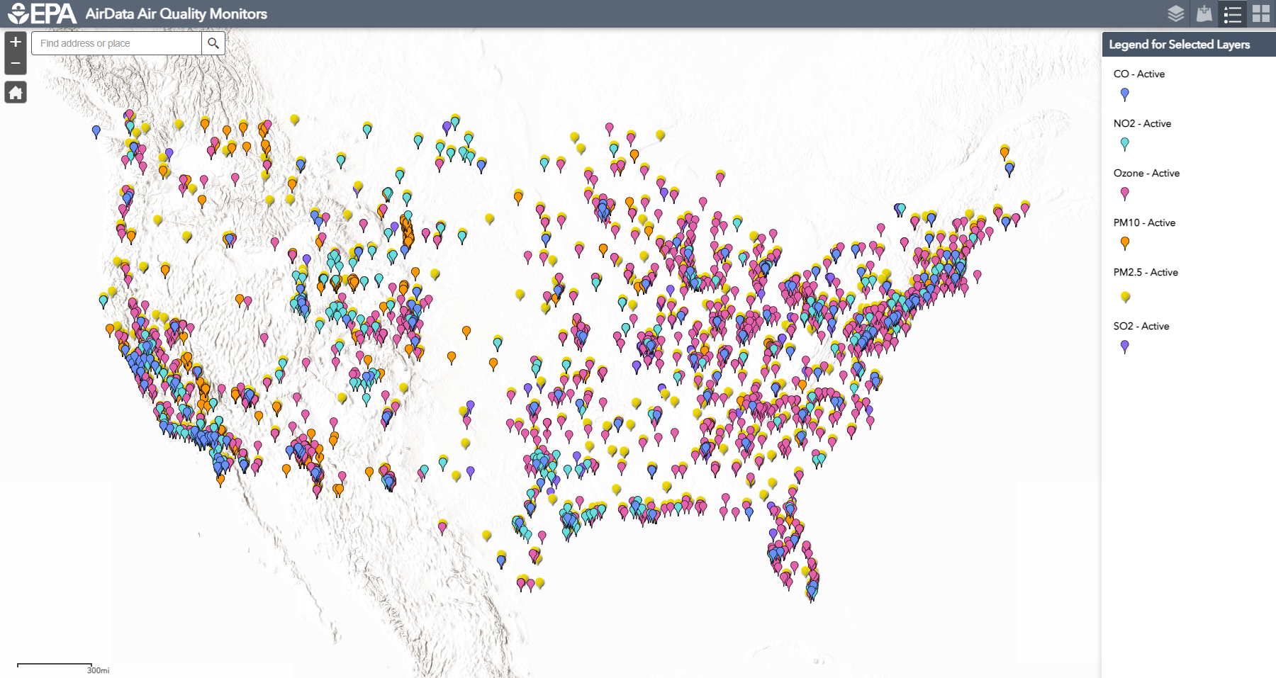
This data comes from a combination of satellites and ambient monitoring stations on the ground that measure pollutant concentrations over a 24-hour window (PM2.5, PM10, CO, NO2, SO2, and O3). The locations of these monitors are determined by the environmental agencies of individual states, who are each responsible for creating their own air monitoring plans and usually place them near large population centers or areas believed to have higher pollutant concentrations (see Figure 2).
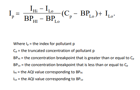
To calculate the AQI, scientists use ambient monitoring data for at least three of the eight pollutants (one must be PM2.5 or PM10). They also use breakpoint concentration ranges for each pollutant, which are predefined concentration ranges established by regulatory agencies or health organizations. Each breakpoint is associated with a specific range of pollutant concentrations and an AQI value. The 24-hour average concentration values (or 8-hour averages for CO and O3) and health breakpoint concentration ranges are used to calculate sub-indices for each individual pollutant. The highest sub-index during the period becomes the AQI for that location. In other words, the worst pollutant “wins”. In mathematical terms, this process is represented by the equation shown in Figure 1.

Figure 1. Equation to calculate AQI. Source: airnow.gov.
The Importance of Ambient Air Monitoring
Ambient monitoring is a crucial tool for ensuring the health of our communities. By systematically monitoring air quality in different areas, authorities can identify the pollutants of concern and issue timely warnings to the public. This allows individuals to take appropriate precautions and adapt their behavior to protect their wellbeing.

Figure 2. Location of Air Quality Monitors for Criteria Pollutants. Source: EPA interactive map.
However, as shown in Figure 2, the United States is not evenly covered with air monitoring equipment. Areas with fewer residents, or that have not received prior attention from pollution events, may not be “on the radar” for state monitoring plans.
The increasing threat of wildland fire demands a comprehensive understanding of the dangers posed by wildfire smoke. Ambient air monitoring is essential in providing timely information about the pollutants present in each area, empowering individuals and communities to take appropriate actions to safeguard their well-being during wildfire events. Whether it’s to respond to a wildfire-related pollution event, or to simply monitor the air in your community to develop a better understanding of its air quality, CleanAir can provide what you need.
The CleanAir Advantage
CleanAir offers a wide range of products and services related to air quality monitoring, from full-scale monitoring stations to small hand-held monitors. For example, our Aeroqual monitors are portable and cost-effective, and provide actionable, defensible data when quality assured frequently and used in accordance with U.S. EPA monitoring guidelines.
Research shows that outdoor workers may be particularly vulnerable to wildfire smoke exposure. If you are an employer looking to protect your employees from adverse health effects from smoke exposure, CleanAir also offers handheld Wildfire Smoke Monitoring Kits that are affordable and easy to use.


